To be listed as UNESCO World Heritage Sites, states parties are encouraged to submit their tentative list, an inventory of those properties which each State Party intends to consider for nomination.
The list could be properties which they consider to be cultural and/or natural heritage of outstanding universal value and therefore suitable for inscription on the World Heritage List.
For the past’s years, Southeast Asian nations did submit application to the UNESCO, which their lists should not be considered exhaustive, to the World Heritage Centre, at least one year prior to the submission of any nomination.
Keen to know which properties or sites that were nominated?
Resembling each nations in the region, herewith are potential sites that might be considered as next UNESCO World Heritage Sites and their justifications of outstanding universal value:
INDONESIA
HISTORICAL CITY CENTRE OF YOGYAKARTA
Application submission year: 2017


The historic city centre of Yogyakarta was built as a representation of microcosmos based on the Javanese cosmology and philosophy. This was manifested in its specific location in the wider landscape as well as the plan of the city centre.
The city is situated between Merapi Volcano and the South Sea and flanked by three rivers each to the east and west. Such a landscape is perceived as the replica of the Universe and indeed an ideal place to establish the Kraton (Palace) as the centre of the Sultanate of Yogyakarta which is also considered as the centre of the world.
The plan of the historical city centre of Yogyakarta was designed by the Hamengkubuwana I to signify the human life cycle, from the very beginning of human life to the reunification of the soul with the God. This universal value has been embodied in the main components of the city centre along the so-called philosophical axis of Yogyakarta.
In addition, some particular components of the city centre also represent the other basic concepts of human nature, i.e. to maintain harmonious relations between God – Human – Nature through manunggaling kawulo gusti (unity of God with Human as well as the King with his people) and to create a peaceful and beautiful world.
The Javanese philosophy implemented in the plan of the historical city centre of Yogyakarta is indeed a blend of local wisdom, Hinduism, and Islam as a result of intensive cultural interaction of different civilizations in Java. Certainly, those are of significant universal values.
MALAYSIA
ROYAL BELUM STATE OF PERAK, MALAYSIA
Application submission year: 2017


The State Park is part of the Peninsular Malaysian Central Forest Spine (CFS) covering an area of 27,891 ha.
It has been considered as the hotspot for biodiversity in Malaysia as it hosts diverse ecosystems and habitats for the many species of flora and fauna of which many of them are endemic, rare, vulnerable or otherwise threatened in Malaysia and the region.
These augur well for environmental education of the ecosystems therein and scientific research in biodiversity not only for Malaysians but also those in the region and the World. It can be considered as another natural gift to the heritage of mankind.
Topographically and geologically, the Royal Belum State Park represents the northern tip of the Main Range (Banjaran Titiwangsa), the backbone of Peninsular Malaysia where nature (i.e. exogenic or surface processes) had crafted the landforms dynamically for over 200 million years.
The mountain range acts as the divider between the west and east coast of Peninsular Malaysia, and is extended for more than 480 km to the south to North Johor area.
To its east, the Main Range granitic rock intruded a belt of 25 km wide of highly metamorphosed rocks. These metamorphic rocks were interpreted to have originated from Ordovician to Permian shallow to deep marine sediments that belonged to the East Malaya Block with strong Cathaysia affinity.
This was the unique geological meeting area of the southern Gondwanaland supercontinent and the northern Laurasia supercontinent. In South-east Asia this is the most significant landmass for the evolution of the tropical geology and biodiversity.
These geological formations have become the substratum or the template for the ever-pristine vegetation of those era until today and the forests had housed the oldest, rich and diverse flora and fauna of tropical humid biome.
THAILAND
PHRA THAT PHENOM, ITS RELATED HISTORIC BUILDINGS AND ASSOCIATED LANDSCAPE
Application submission year: 2017

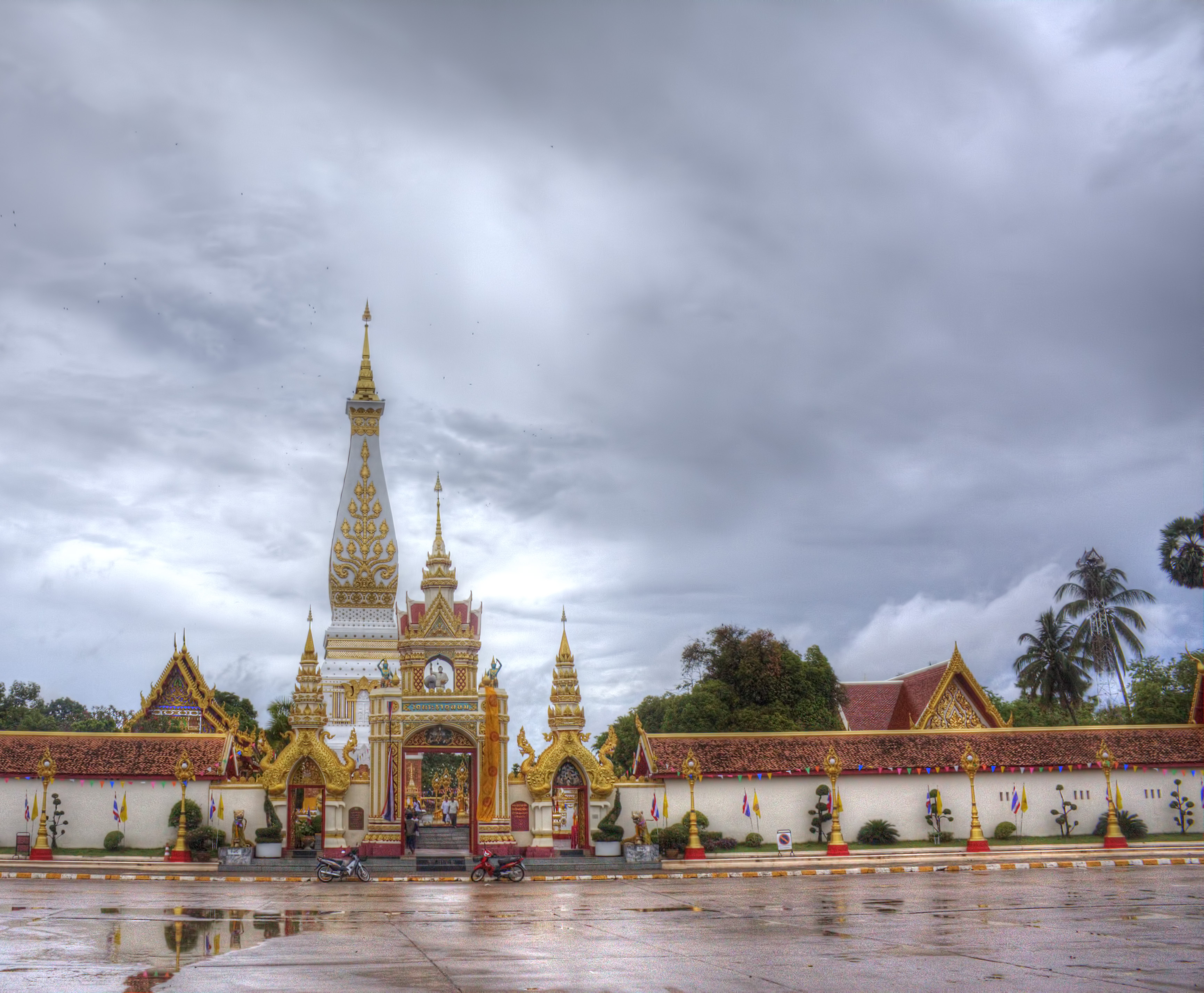
Phra That Phanom represents the noblest and the most conscious form of Buddhist architectural and artistic expressions in the Mekong region, in Thailand, and especially in the Northeast region of the country. The Monument embodies the essence of Buddhism as interpreted and embraced by the people in the region since time immemorial.
A creative architectural response to the undying faith and spirituality of the people, Phra That Phanom Stupa exhibits a unique achievement, combining the traditional grammar of sacred representation of the ancient Chams and Khmers, with the traditional elements of Buddhist Relics Stupa architecture and symbolism from India, while also blending in the Mekong regional spirit as well as the local artistic ornamentations.
This Stupa has thus become the most distinguished and tangible symbol of the spiritual identity of the region, an inspiration too many other Buddhist Stupas constructed later in Nakorn Phanom as well as in the greater Northeast of Thailand.
Phra That Phanom has furthermore inspired the design and creation of many local folk arts and crafts, such as the "ancestor's relics shrine" commonly produced and used by the village folks in this region, and souvenir stupas and motive for individual veneration. It has also been adopted as the major design of the Khon Kaen University's Emblem and in Thai national stamps.
LAOS
HIN NAM NO NATIONAL PROTECTED AREA
Application submission year: 2016

The project in the Hin Nam No regions is part of the programme named “Climate-relevant environment and resource management in Laos” | Travel to Indochina
Hin Nam No NPA is considered of outstanding universal value for the evolution of its complex and spectacular karst landscape and its variety of habitats that support high biodiversity, including a number of globally threatened species, endemic species and karst specialist species.
The complexity and diversity of geologic and geomorphologic features on display in Hin Nam No NPA provide an outstanding example of major stages in the formation of a mature and spectacular karst landscape.
The geologic history of the exposed rocks dates back to the early Carboniferous period (350 Ma), with the karst geomorphology evolving to the present day. The Khammouane Formation, the 1100 m thick principal limestone sequence, was formed during the middle Carboniferous to early Permian period. Morphogenetic evolution of the karst is the result of a complex tectonic history.
The lndosinian orogeny occurred in the middle Triassic (247 Ma). This significant compression, uplift, and erosion episode affected much of Southeast Asia, bringing many carbonates into subaerial positions, and resulting in a prolonged karstification episode. The karst was subsequently buried under thick layers of late Triassic, Jurassic and early Cretaceous sandstones and shales.
A new uplift began in the Paleogene (65 Ma), leading to large scale erosion.
As the limestone became progressively re-exposed karst evolution resumed in earnest. lndosinian karst landforms have been exhumed and rejuvenated and play a significant role in the evolution of the modern karst.
PHILIPPINES
TURTLE ISLANDS WILDLIFE SANCTUARY
Application submission year: 2015
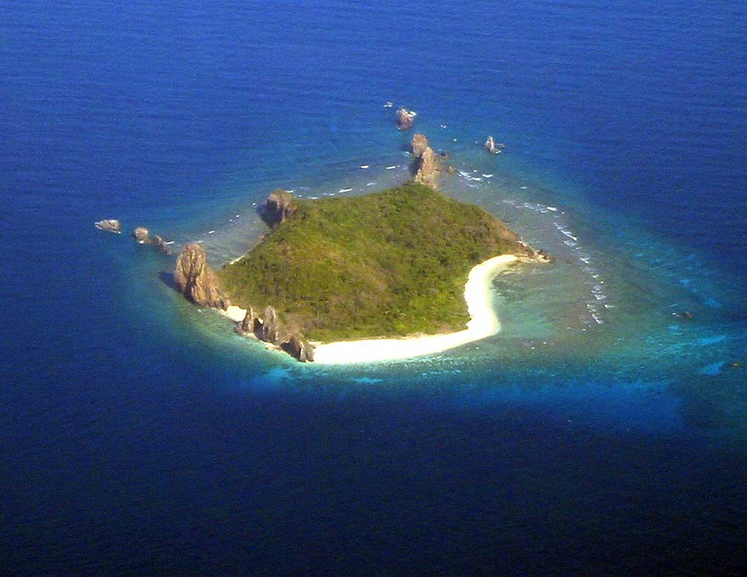
It was proclaimed as Wildlife Sanctuary under Proclamation No. 171 on August 26, 1999, and identified as Extremely High (EH) for biodiversity conservation.
The only major nesting habitat of Green sea turtles (Chelonia mydas) in the Philippines and the only major nesting ground in the whole ASEAN Region and the 11th major nesting site in the world. Marine Turtles play an important role in the marine ecosystem as it maintains a healthy coral reef and seagrass that serves a breeding ground for fishes and small crustaceans.
On May 31, 1996, a Memorandum of Agreement (MOA) between the Republic of the Philippines and the Government of Malaysia was signed declaring Turtle Islands as Turtle Islands Heritage Protected Area (TIHPA), the first transboundary protected area on sea turtles in the world aiming for the conservation and protection of the area. During peak season, 80-150 turtles laid eggs every night from May-July.
The Hawksbill Turtle (Eretmochelys imbricata) also occur but with a low-density nesting in contrast to the Green Turtle. On flora diversity, 200 species have been identified, of these, 10 mangrove species have been seen growing in Boan and Taganak Island, while 19 species of ferns are found in all the six islands. Thirty-four avian species have been observed to occur in the entire Turtle Islands.
Turtle Islands Wildlife Sanctuary was included in the launching of Model Marine Protected Area Network (MPA network) on May 14-15, 2014 at Manado Indonesia. It aims to safeguard Marine Turtle and their habitats. Working on connectivity and operating cooperatively in the Coral Triangle Initiative CTI), Sulu Sulawesi Marine Ecoregion (SSME).
CAMBODIA
ENSEMBLE DE BANTEAY PREI NOKOR
Application submission year: 1992

The temple complex of Banteay Prey Nokor is especially known by the temple of Wat Nokor located in Khum of Kompong Siem, at a distance of 1200 meters from the town of Kompong Cham. The monument was built out of sandstone and laterite and dates from the last years of the reign of Jayavarman VII.
It is composed of a central tower surrounded by four laterite wall-enclosures. The central tower of the temple of Vat Nokor is decorated with motifs characteristic of Bayon with Buddhist scenes on the pediments. The temple complex is also believed to have been the headquarters of Jayavarman VII for a time, from where he extended his influence over nearby principalities.
The local people sometimes call the temple 'Wat Angkor' though a sign at the entrance of the temple now officially designates the name of the temple as Wat Nokor Bachey.
The temple has a number of distinguishing characteristics other than the fact that it is the largest ancient temple complex in Kampong Cham Province. One of these characteristics alludes to the fact that it is built of black sandstone, which causes it to stand out from other temples of the period which are often built of brick or reddish sandstone.
The temple has an inscription which is still open to visitors to see (and even touch) in the temple's central pavilion. The temple also boasts a 'Chartre' effect in which another more modern temple of a very different style has been built over and around the original Angkorian structure creating a blend of architectural styles.
Vietnam, Brunei and Singapore, however, haven’t so far submitted any recent application for nominations to the World Heritae List, to date.
Source :UNESCO Official Website