

UNESCO Global Geoparks (UGGp) are integrated geographical areas where sites and landscapes of international geological significance are managed using a holistic approach that includes protection, education and sustainable development. This approach involves local communities and is growing in popularity. There are currently 195 UNESCO Global Geoparks in 48 countries.
Since its inception in 2015, the UNESCO Global Geopark label has come to recognize geological heritage of global significance. These geoparks aim to serve local communities by combining the preservation of their geological heritage, public outreach, and the implementation of a sustainable development approach that encompasses various aspects of life. In Southeast Asia in particular, the region has made a significant contribution in terms of the number of top global geoparks, with a total of 18 geoparks.
Bohol Island, The Philippines

Bohol Island in the Philippines has become the country's first UNESCO Global Geopark. Covering 8,808 square kilometers, UNESCO Global Geopark Bohol Island surrounds a protected marine area. It contains stunning karst geosites such as caves, sinkholes, and the iconic Chocolate Hills. The island's geological identity has been formed over more than 150 million years.
Dak Nong, Viet Nam

The UNESCO Dak Nong Geopark in Dak Nong Province, Vietnam, covers an area of 4,760 square kilometers and includes five districts (Krong No, Cu Jut, Dak Mil, Dak Song, Dak G'long) and Gia Nghia City. The Geopark is famous for its unique geological features and provides chances for sustainable progress, such as safeguarding cultural heritage, boosting local goods, and fostering eco-tourism.
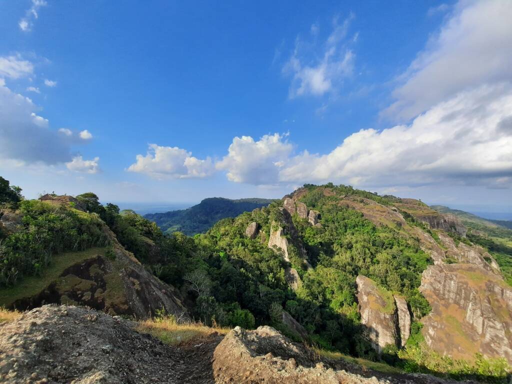
Non Nuoc Cao Bang, Viet Nam

Non Nuoc Cao Bang UNESCO Geopark in Cao Bang Province, northern Vietnam, covers an area of 3,683 square kilometers. The region is inhabited by about 250,000 people, 92% of whom belong to nine different ethnic groups. Non Nuoc Cao Bang Geopark is the second geopark recognized by UNESCO in Vietnam, after Dong Van Karst Plateau Geopark.
Dong Van Karst Plateau, Viet Nam

Dong Van Karst Plateau UNESCO Geopark, located in Ha Giang Province, northeastern Vietnam, covers an area of 2,356.8 square kilometers. Located in the foothills of the eastern Himalayas, the Geopark is famous for its diverse geological features, including paleobiology, stratigraphy, geomorphology, tectonics, karst, caves, and major faults. The geology of the Geopark reflects major events in Earth history, including two mass extinctions.
Batur, Indonesia

Batur UNESCO Global Geopark is located in the northeast of Bali, an island that is one of Indonesia's most famous international tourist destinations. The Geopark covers an area of 370.5 square kilometers and ranges in altitude from 920 to 2152 meters above sea level. Many areas within it, such as Gunung Batur Nature Park and Bukit Payang, are part of the protected forests that are an important part of this UNESCO Global Geopark.
Maros Pangkep, Indonesia

Maros Pangkep, a UNESCO Global Geopark in South Sulawesi, Indonesia, is known for its stunning views of karst formations, which can be explored through the Gua Aloa Kalibong geosite. The geopark covers an area of approximately 5,077.25 square kilometers and stretches from land to sea, with altitudes ranging from 0 to 1,300 meters above sea level.
Merangin Jambi, Indonesia

Covering an area of 4,832.31 square kilometers, Merangin Jambi in Jambi Province, Sumatra Island, Indonesia, is a UNESCO Global Geopark famous for its unique "Flora Jambi" fossils, which reflect the characteristics of West Sumatran terrestrial flora and Euramerican flora. The Geopark has a few main geological features, including a Mesozoic karst landscape with prehistoric artifacts, and the Masurai Caldera representing Quaternary volcanoes.
Raja Ampat, Indonesia

The Raja Ampat Geopark, located in Raja Ampat Regency, Southwest Papua, Indonesia, is a UNESCO Global Geopark that contains the oldest rocks in Indonesia from the Silurian-Devonian period, approximately 443.8-358.9 million years ago. The Geopark has eight terrestrial protected areas and covers an area of 2,713 km2, surrounded by Regional Marine Protected Areas and National Marine Sanctuaries.
Mount Rinjani, Indonesia

Rinjani-Lombok UNESCO Geopark is located on the island of Lombok, Southeast Asia, and covers 41,330 hectares (159.6 square miles) of national park and catchment area. The Geopark is located in the Lesser Sunda Islands, also known as the Nusa Tenggara Islands, and features the geological and cultural significance of Mount Rinjani, an active volcano in Indonesia located on the island of Lombok.
Toba Caldera, Indonesia

The Toba Caldera UNESCO Geopark, in the province of North Sumatra, Indonesia, is located around Lake Toba, which was formed 74,000 years ago by a massive volcanic eruption. This eruption was the largest of the Quaternary period and produced 2,800 km3 of pyroclastic material. The event also gave the Toba Caldera Geopark its name, referring to the rocky space that formed after the eruption, creating a remarkable geopark landscape that was once filled with water and the fertile surrounding area developed into what it is today.
Belitong, Indonesia

Belitong Geopark, located in Bangka Belitung Province, Indonesia, covers an area of 4,800 square kilometers of land and 13,000 square kilometers of sea, surrounded by 241 small islands. The mainland consists mainly of hills surrounded by lowlands, with altitudes as low as 0 meters above sea level. Belitong Geopark is famous for the TOR Granite Landscape, a unique geological feature in the Southeast Asian Tin Belt.
Gunung Sewu, Indonesia
Gunung Sewu Geopark is located in the southern mountains of East Java, Indonesia, stretching from Gunung Kidul and Wonogiri Regency, Central Java, to Pacitan Regency, East Java. The Geopark is known for its tropical karst areas, which are unique in Southeast Asia, as well as karst ecosystems and areas where ancient human fossils from the Paleolithic period, about 1.8 million years ago, and stone tools for hunting have been found.
Ciletuh, Indonesia

Ciletuh-Palabuhanratu Geopark is a UNESCO Global Geopark in Pelabuhan Ratu, Sukabumi Regency, West Java, Indonesia, covering an area of 128,000 hectares and including eight subdistricts and 74 villages. The name of the Geopark is inspired by the Ciletuh River and Palabuhanratu (Pelabuhan Ratu), which is related to the legend of the Queen of the Southern Ocean as the guardian of this area. It is a famous tourist destination with sites such as Puncak Darma, Curug Sodong, Curug Awang, Palangpang Beach and Bukit.
Ijen, Indonesia

Ijen Geopark in East Java, Indonesia, is a UNESCO Global Geopark covering an area of 1,300 square kilometers. The Ijen area is formed by three distinct mountain ranges, including the Giant Volcano Complex in the north and the Ancient Volcano Hills in the southwest. Within this geopark is Mount Ijen, famous for its blue fire scenery.
Khorat, Thailand

Khorat UNESCO Geopark is located in Nakhon Ratchasima Province, Northeast Thailand, and covers an area of 5 out of 32 districts in the province, with a total area of 3,000 square kilometers. Khorat Geopark is known for its unique geological features, including the Khao Chan Ngam sandstone and the Pha Kep Ta Wan rock formation. The geopark is also home to several important cultural sites, including the Ban Prasat Archaeological Site and the Hin Phimai Prasat Historical Park.
Satun, Thailand

UNESCO Satun Geopark in the southern Thai province of Satun covers four districts, including Thungwa, La-ngu, Manang, and parts of Mueang Satun, and includes two national parks and a wildlife sanctuary. The region is rich in mountains, foothills, beaches, and islands along the Andaman Sea. The population is approximately 113,110 people, with the majority of the population being of Thai origin, while there are also diverse cultural and religious groups.
Langkawi, Malaysia

Langkawi UNESCO Global Geopark, located at the northwestern tip of peninsular Malaysia, covers an area of 99 islands with a total area of 470 square kilometers. The uniqueness of this Geopark lies in its geological and cultural heritage, including traditional fishing and farming villages. Located along the Strait of Malacca, which was a historic trade route in Southeast Asia, the Geopark has many legends, myths, and historical links with the surrounding area.
Kinabalu, Malaysia

Kinabalu Geopark in the state of Sabah, Malaysia, is a UNESCO Global Geopark covering an area of 4,750 km2. The Geopark is named after Mount Kinabalu, the highest peak in Southeast Asia, which dominates the region. One of the distinguishing features of Kinabalu Geopark is its distinctive hornblende granite peaks with fine-grained hornblende minerals. It is also home to incredible biodiversity, including many species found only in this region.


