


From the deck of a ship crossing the Makassar Strait, all you can see is dark blue water stretching between the coasts of Kalimantan and Sulawesi, occasionally broken by coal barges.
There is no sign on the surface of what flows far below: one of the planet's most powerful “rivers.” It moves swiftly and relentlessly, carrying warm water from the heart of the Pacific toward the Indian Ocean.
Scientists call it the Indonesian Throughflow or ITF. Its influence extends far beyond Indonesian waters.
The Warmest Waterway Connecting Two Oceans
Picture a map of the world from above. The Pacific and Indian Oceans should be almost completely sealed off from each other by the landmasses of Asia to the north and Australia to the south.
But between them, nature left an opening: Indonesia's thousands of islands, narrow straits, and deep ocean channels. Together, they form the only major passage through which tropical water can flow directly from one ocean to the other.
The water originates in the Western Pacific Warm Pool, the hottest region of ocean ever recorded on Earth. From there, it moves through Indonesia's maze of seas before eventually spilling into the eastern Indian Ocean.
Because it carries enormous amounts of heat between two oceans, oceanographers describe the ITF as a warm branch of the Great Ocean Conveyor Belt. This vast circulation system redistributes heat throughout the world's oceans, from the equator toward the poles.
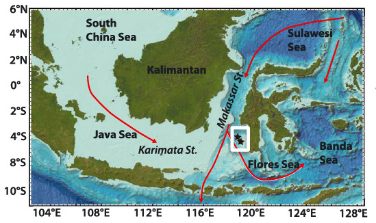
Of all the available passages, one route dominates: the Makassar Strait.
Around 12 to 13 million cubic meters of water flow through it every second, equivalent to 12–13 Sverdrup. A Sverdrup is the unit oceanographers use to measure massive ocean currents. The flow accounts for roughly 77–80 percent of the ITF's total volume, which averages around 15 Sverdrup.
Much of this water is funneled through a narrow passage called the Labani Channel. At around 45 kilometers wide, it lies in the middle of the Makassar Strait and carries roughly 80 percent of the water flowing through the strait—like the neck of a giant bottle in the middle of the ocean.
From the Makassar Strait, the current moves south through the Flores Sea and into the Banda Sea. There, it mixes with flows from the eastern route entering through the Molucca and Halmahera Seas.
The combined waters eventually reach the Indian Ocean through three main gateways: the Lombok Strait (around 2.6 Sverdrup), the Ombai Strait (around 4.9 Sverdrup), and the Timor Passage (around 7.5 Sverdrup).
When El Niño and La Niña Join the Equation
A current this powerful is far from stable. Its strength rises and falls with two of the Pacific's most influential climate patterns: El Niño and La Niña.
During La Niña, stronger Pacific trade winds raise sea levels in the western Pacific, pushing more water toward the Makassar Strait and accelerating the ITF. When El Niño arrives, that push weakens, and so does the ITF.
But researchers have found that this seemingly simple relationship is much more complicated.
A team led by Xu, in a 2025 study published in Geophysical Research Letters, examined how the 2015/2016 Super El Niño, one of the strongest on record, disrupted the ITF through two separate pathways that almost worked in opposite directions.
From the west, Kelvin waves traveling from the Indian Ocean raised sea levels south of Java and disrupted currents in the upper layers of the Makassar Strait.
From the east, slowly moving Rossby waves traveled westward and downward from the central Pacific, disturbing deeper waters below the thermocline. There, the current pattern was almost the reverse of what was happening at the surface.
Another study, published Geophysical Research Letters (August 2025), revealed a surprise from a different direction. The 2020–2023 “triple-dip” La Niña, three consecutive years of La Niña, an unusually rare event in the historical record—should, in theory, have caused the ITF to strengthen sharply.
Instead, the increase was modest: just 0.3 Sverdrup above the 12-Sverdrup average.
The culprit was a negative Indian Ocean Dipole that coincided with the third year of La Niña. It strengthened westerly winds and raised sea levels in the eastern Indian Ocean, effectively pushing back against the Pacific's influence from the other side.
Model simulations put the effect into numbers: Indian Ocean winds dampened up to 51 percent of the variability that would otherwise have been driven by the Pacific.
It was a quiet tug-of-war between two oceans, unfolding beneath the ships moving through the Makassar Strait.
What Happens as the Planet Keeps Warming?
The bigger question is what happens to the ITF in a warming world. A recent study, published in the same journal in 2026, offers an answer that runs against intuition.
The total volume of water flowing through the ITF is projected to decline as global temperatures rise. Yet the amount of freshwater carried by the current is expected to increase, as rainfall over Indonesia is projected to become heavier.
The reasons come from two seemingly unrelated parts of the world.
In the Pacific, changing wind patterns are expected to shift surface currents southward, reducing the flow entering through the Halmahera Sea.
But the more surprising influence comes from the other side of the planet.
A weakening Atlantic Meridional Overturning Circulation (AMOC), the vast system of currents in the Atlantic, which is also expected to slow as the planet warms could trigger Kelvin waves that travel thousands of kilometers across two oceans and reach Indonesian waters.
These waves would weaken currents in the thermocline and intermediate layers of the Makassar Strait and the Molucca Sea.
In other words, what happens off the coasts of Greenland and Iceland could send ripples all the way to the heart of the Indonesian archipelago.
It is a reminder that the Makassar Strait, narrow as it may seem, is just one small node in a global ocean circulation system that connects and helps regulate the temperature of the entire planet.


