

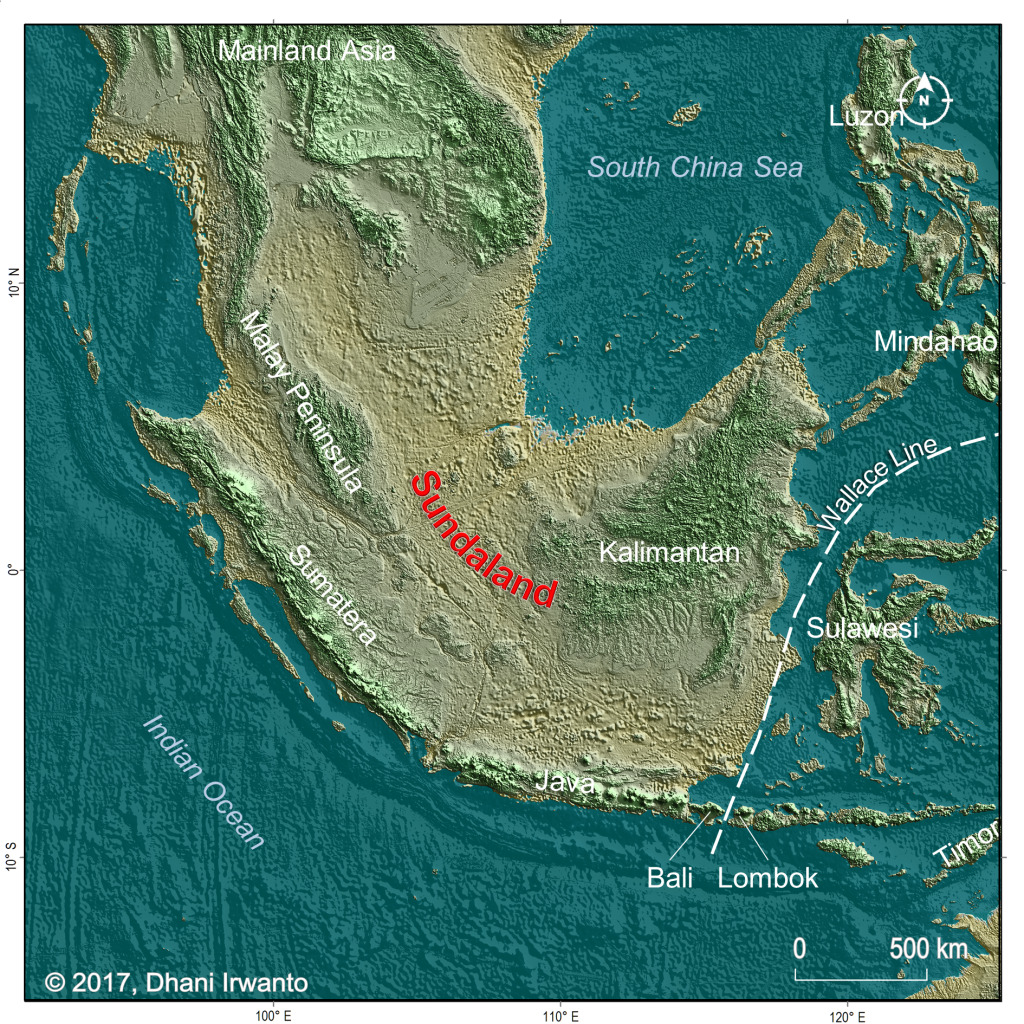
Around 21,000 years ago, sea levels across Southeast Asia were approximately 120 meters lower than they are today. As a result, vast stretches of seabed that are now known as the Java Sea, the Strait of Malacca, and parts of the South China Sea were exposed above the water as dry land.
The result was a vast tropical continent known as Sundaland. It connected the Malay Peninsula, Sumatra, Borneo, and Java into a single continuous landmass without interruption.
At its maximum extent, Sundaland is estimated to have covered around 4 million square kilometers, roughly equivalent to the combined area of the Amazon rainforest and the Congo Basin today. It possessed its own river systems, lakes, and vegetation, and served as a home for prehistoric human populations for thousands of years before it was eventually submerged.
One Landmass, Four Major River Systems
During the existence of Sundaland, the Sunda Shelf (now hidden beneath the sea) was crossed by at least four major river systems: the Malacca River, the Siam River, the North Sunda River, and the East Sunda River.
These rivers flowed across land that is now submerged beneath the ocean, forming major corridors for the movement of wildlife and human populations.
Paleogeographic reconstructions using high-resolution bathymetric data from GEBCO 2023 have successfully remapped these ancient river networks and confirmed the presence of large lakes in what is now the Gulf of Thailand.
Sundaland as a whole covered only about 4 percent of the Earth’s land surface, yet it contained an estimated 20–25 percent of the planet’s plant and animal species.
Its vegetation was not uniformly rainforest. A 2024 study published in Quaternary Science Reviews found that the continent’s interior was covered by a mixture of open grasslands and monsoon forests.
Meanwhile, the southern regions were dominated by tropical wet forests, driven by shifts in seasonal rainfall patterns caused by the emergence of new land areas that altered regional atmospheric circulation.
The Great Flood That Split a Continent
The submergence of Sundaland was not a slow and uniform process. Between 21,000 and 6,000 years ago, global sea levels rose by approximately 130 meters in total. However, the most dramatic increases occurred during two brief and extreme meltwater pulses.
The first, known as Meltwater Pulse 1A, took place around 14,600 years ago, when sea levels rose by as much as 16 meters in just 300 years.
For context, the rate of sea-level rise during this period reached 40–60 millimeters per year, far exceeding the modern rate of approximately 3–5 millimeters per year.
The second event, Meltwater Pulse 1B, occurred around 11,500–11,000 years ago and once again submerged millions of square kilometers of land.
Together, these two flooding events reduced Sundaland’s area by more than 50 percent from its extent during the Last Glacial Maximum. The land bridge connecting Borneo to the Malay Peninsula was severed. Sumatra and Java became separate islands.
What remained was the archipelagic landscape we know today.
The World’s First Climate Refugees
The people who inhabited Sundaland had little choice but to move. A study published in Communications Biology in 2023 by researchers from Nanyang Technological University analyzed genomic data from 763 human genomes representing 59 ethnic groups.
The findings suggest that ancient sea-level rise directly triggered large-scale human migration out of Sundaland.
Among the earliest groups affected were the Orang Asli, or Malaysian Negrito communities. As their ancestral lands were submerged and populations became compressed into increasingly restricted areas, they migrated northward toward mainland Asia and South Asia.
The researchers described this as “the earliest documented instance of forced human migration driven by sea-level rise.”
The genetic legacy of this event remains visible today.
Much of the ethnic diversity found across South Asia and Island Southeast Asia is the result of mixing among fragmented Sundaland populations that later dispersed and assimilated across different parts of the region.
Sundaland was not merely a lost landmass. It was a point of origin for the human geography that much of Southeast Asia inherits today.
Reference:
- Cheng, S., & Faidi, M. A. (2024). Palaeodrainages of the Sunda Shelf detailed in new maps. Journal of Palaeogeography, 14, 186–202. https://www.sciencedirect.com/science/article/pii/S2095383624001184
- Dixit, N. M., Zirpel, M., Slik, J. W. F., Jamsari, J., Weising, K., & Guicking, D. (2023). Biogeography of the Sunda Shelf revisited: Insights from Macaranga section Pruinosae (Euphorbiaceae). Frontiers in Ecology and Evolution, 10, Article 1049243. https://doi.org/10.3389/fevo.2022.1049243
- Hanebuth, T., Stattegger, K., & Grootes, P. M. (2000). Rapid flooding of the Sunda Shelf: A late-glacial sea-level record. Science, 288(5468), 1033–1035. https://doi.org/10.1126/science.288.5468.1033
- Huang, E., Yuan, Z., Wang, S., Yang, Y., Jia, G., & Tian, J. (2024). Expansion of grasslands across glacial Sundaland caused by enhanced precipitation seasonality. Quaternary Science Reviews, 337, Article 108609. https://doi.org/10.1016/j.quascirev.2024.108609
- Kim, H. L., Li, T., Kalsi, N., Nguyen, H. T. T., Shaw, T. A., Ang, K. C., Cheng, K. C., Ratan, A., Peltier, W. R., Samanta, D., Pratapneni, M., Schuster, S. C., & Horton, B. P. (2023). Prehistoric human migration between Sundaland and South Asia was driven by sea-level rise. Communications Biology, 6(1), Article 150. https://doi.org/10.1038/s42003-023-04510-0


