


By mid-2026, Chinese and Philippine coast guard vessels were again confronting each other around Scarborough Shoal. Water cannon blasts, ships cutting across each other’s paths, and joint military exercises involving the United States, the Philippines, and Japan had become recurring scenes throughout the year.
Amid the tensions, the “weapon” most often cited by the Philippine government is not a warship, but a nearly 300-year-old map now kept at the National Library of the Philippines.
A Map Born from a Royal Order
It began with a request from King Philip V of Spain on June 1, 1729, to produce an accurate map of the Philippines.
The task passed to Governor-General Fernando Valdés Tamón and eventually to Pedro Murillo Velarde, a Jesuit priest, legal scholar, and geographer. He was assisted by Filipino artist Francisco Suarez, who drew the map, and Filipino engraver Nicolas de la Cruz Bagay, who transferred it onto copper plates for printing.
Completed in 1734, the Carta Hydrographica y Chorographica de las Yslas Filipinas was later dubbed the “Mother of All Philippine Maps.” It was the first scientifically compiled and comprehensive map of the Philippine archipelago, combining earlier maps, navigators’ records, and Murillo Velarde’s own voyages to remote islands to verify incomplete data.
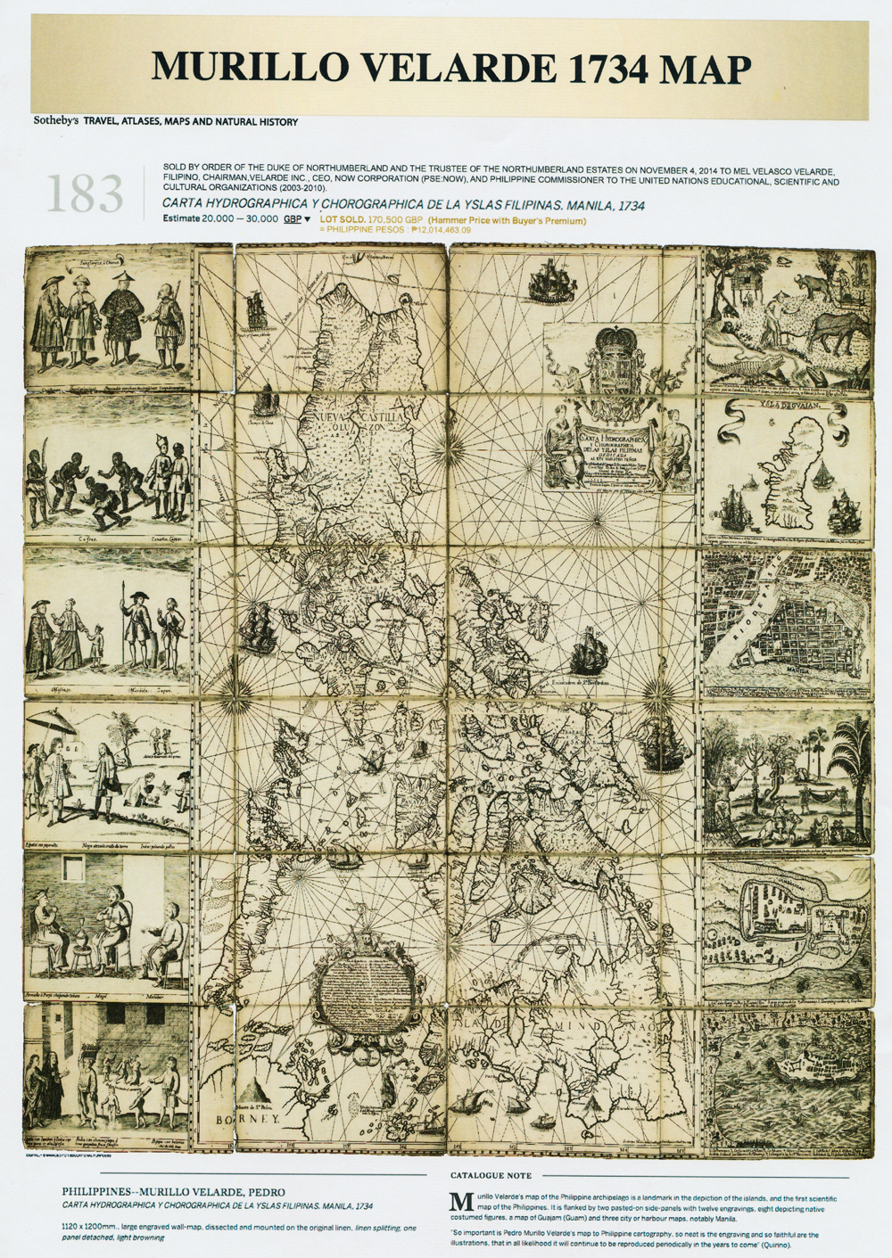
Its significance lies not only in its accuracy, but also in what it depicts. Two features now central to the South China Sea dispute are clearly shown as part of the “Islas Filipinas”: Panacot, the former name for Bajo de Masinloc, now known as Scarborough Shoal or Panatag Shoal, and Los Bajos de Paragua, the Spratly Islands.
This was more than two centuries before China’s dotted-line claim emerged. Its precursor, the eleven-dash line, first appeared in 1947 under the Republic of China government and was revised into the nine-dash line by the People’s Republic of China in 1953.
From a British Nobleman’s Cabinet to the President’s Desk
The map’s journey was long and winding. One copy entered the collection of the British aristocratic Dukes of Northumberland and was put up for public auction after severe flooding hit Northumberland County in 2012, prompting the family to sell some inherited collections.
On November 4, 2014, Filipino businessman Mel Velarde, who is unrelated to the cartographer, won the Sotheby’s auction in London for £170,500 and donated the map to the Philippine government.
The original was formally handed to President Ferdinand Marcos Jr. at Malacañang on December 6, 2024, and has since been permanently displayed at the National Library of the Philippines. On December 11, 2025, the institution designated the 1734 Murillo Velarde map as a National Cultural Treasure.
In February 2026, two “miniature” copies dated 1744 and 1788 appeared at an auction at Leon Gallery in Makati. Measuring one-quarter the size of the original, they were also hand-engraved by Nicolas de la Cruz Bagay, adding to the historical documentation surrounding the map.
Evidence in Court, But Not the Basis of the Verdict
So, did this map help the Philippines win its case against China? The answer requires some clarification.
In 2013, the Philippines brought its case before the Permanent Court of Arbitration (PCA) in The Hague. The legal team, led by former Supreme Court Justice Antonio Carpio, submitted more than 270 historical maps as supporting evidence. The Murillo Velarde map was among the oldest and most compelling.
But when the tribunal issued its ruling on July 12, 2016, its legal basis was the United Nations Convention on the Law of the Sea (UNCLOS), not the ancient maps. It ruled that China’s historic rights claim to resources within the nine-dash line had “no legal basis” and that UNCLOS does not allow an island group such as the Spratlys to be treated as a single unit generating maritime zones.
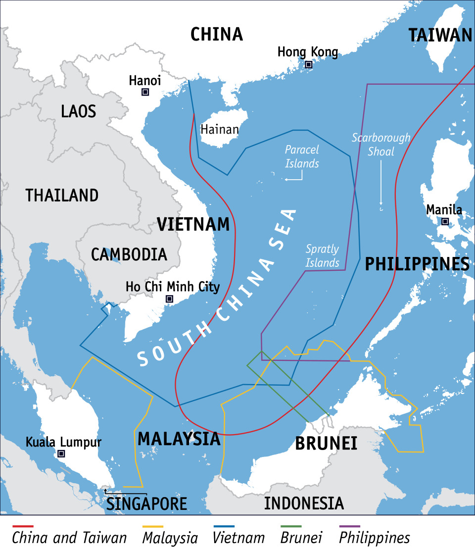
The ruling also did not determine sovereignty over the disputed islands and reefs, including Scarborough Shoal.
Sovereignty refers to legal ownership, while sovereign rights concern the right to exploit resources in a particular area without necessarily having full ownership. The PCA ruling dealt only with the latter, finding that the Philippines has sovereign rights over certain reefs within its exclusive economic zone. Scarborough Shoal itself was described as a traditional fishing ground used by fishermen from several countries, rather than territory the Philippines had “won” outright.
International law expert Romel Bagares therefore cautioned against calling the map “evidence affirming” Philippine sovereignty, as this could create a false sense of security. The Philippines’ 2016 legal victory came from the UNCLOS framework, not from a single map.
The map nevertheless remains relevant. Further historical research by Carpio and institutions such as the Institute for Maritime and Ocean Affairs continues to support the argument that Panacot, Bajo de Masinloc, and Scarborough Shoal refer to the same area since the colonial era, long before the dotted line existed.
Why the Map Keeps Coming Back
If the map did not determine the court’s ruling, why does Manila continue to highlight it? The answer lies in the situation around Scarborough Shoal throughout 2026, which has kept the narrative of “who was here first” relevant.
Chinese coast guard patrols surged from an average of 90 ship-days per month in the first half of 2025 to 156 during the same period in 2026, reaching 216 in a single month.
Water cannon incidents involving Philippine vessels have also continued, including one witnessed by a CNN crew aboard a vessel in July 2026. These incidents have made progress toward a regional Code of Conduct increasingly difficult.
Against this backdrop, the Murillo Velarde map continues to be used. Throughout 2025, replicas were displayed at Philippine embassies from Tokyo and Singapore to New York as part of a public diplomacy effort.
Its role is no longer simply that of an archival document used in court. It has become a recurring symbol of historical claims: the oldest written evidence showing that the people and authorities of the islands knew, named, and administered the waters now under dispute, long before China’s dotted line appeared on paper.


