Dahala Khagrabari was a parcel of Indian-owned land located inside Bangladesh territory. The area of the land was recorded at approximately 0.7 hectares, equivalent to 7,000 square meters. Territorial measurements recorded a land area entirely encircled by the administrative border of a neighboring country.
As an exclave, the location of the land was separated from the mainland of its owner state. The plot of land was surrounded by territorial pockets belonging to two different countries in an alternating pattern. The terrestrial borders formed a land pattern severed from its administrative center.
From a technical geographic standpoint, Dahala Khagrabari was categorized as a third-order enclave, or counter-counter-enclave. The term refers to a territory of one country located inside an enclave of a second country, which itself resided inside an enclave of the first country, all enclosed within the mainland of the second country.
Geographic Structure of a Third-Order Enclave
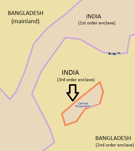
The border structure around the Dahala Khagrabari area consisted of four layers of sovereign territory. The innermost point began with the Dahala Khagrabari plot, which held status as sovereign Indian land.
The Indian parcel lay directly inside the village of Upanchowki Bhajni. The village held status as a Bangladeshi enclave. The boundaries of the village completely encircled the farmland area at its center.
The village of Upanchowki Bhajni was recorded as lying inside the area of Balapara Khagrabari. The area of Balapara Khagrabari was an Indian enclave located in the Cooch Behar District of West Bengal.
The entire series of nested enclaves was situated within Panchagarh District, Rangpur Division. That administrative territory formed part of the mainland of Bangladesh.
The existence of the four border layers placed land management under two different jurisdictions. The physical map layout was officially recorded in the territorial mapping documents of both nations.
Historical Origins of Boundary Delimitation
The background of the territorial line formation originated from a peace treaty in 1713. The treaty was concluded between the ruler of the Cooch Behar Kingdom and representatives of the Mughal Empire.
Both parties ended their territorial dispute by exchanging rights over plots of land belonging to local landowners. The division of land took place without unifying the territorial boundaries.
The fragmented land ownership system remained in place during British colonial rule in South Asia. The colonial government established local administrative borders following the pre-existing traditional mapping.
The Partition of India in 1947 converted the local administrative boundary lines into official international borders. The Kingdom of Cooch Behar subsequently opted to join the Dominion of India in 1949.
Its neighboring territory, formerly under the Mughal Empire, became part of East Pakistan. That East Pakistan region later emerged as the independent nation of Bangladesh in 1971.
The formation of the new state preserved international borders according to the old maps. The arrangement left the status of border land pockets disconnected from the mainland of their respective countries.
Dispute Settlement Through Boundary Agreements
Efforts to resolve the status of the pocket territories were addressed through bilateral diplomatic channels. The governments of India and Bangladesh signed the text of the Land Boundary Agreement in 1974.
The agreement outlined a scheme for exchanging enclave territories alongside establishing permanent land boundaries. The treaty text was officially ratified by the parliaments of both nations in mid-2015.
Under the ratification, Bangladesh received 111 Indian enclaves while India received 51 Bangladeshi enclaves. The transfer of sovereignty over the territories took effect on July 31, 2015.
Through the agreement, Dahala Khagrabari was officially transferred by the Government of India to Bangladesh. The handover automatically altered the administrative status of the land in the border area.
Field records indicate that the Dahala Khagrabari land consists of jute farmland cultivated by a Bangladeshi farmer. The plot is utilized exclusively for agricultural activities without any residential structures.
The sovereign transfer placed the farmland owned by the Bangladeshi citizen now entirely under the legal framework and administrative domain of Bangladesh.